Stellaria angustifolia subsp. angustifolia Hook. APNI* Description: Annual or perennial, weak to tall and spreading to 75–90 cm long, glabrous to scabrous.
Stem and Stem and inflorescence leaves as a continuous series, sessile, linear, narrow-ovate to lanceolate, 9–40 mm long, sometimes longer, 0.9–3.9 mm wide, acute or rarely subacute, margin rarely recurved, occasionally with short hairs.
Inflorescence solitary. Pedicels 15–72 mm long, slender, erect in fruit. Sepals narrow- to broad-ovate or elliptic. Petals 3.5–9 mm long, c. equal to sepals. Stamens 10, filaments 3.3–6.5) mm long.
Capsule ellipsoid to ovoid, 2.8–8.5 mm long, shorter than to equal to sepals or sometimes slightly longer. Seeds 8–33, suborbicular to ellipsoid, 0.6–1.4 mm long, light brown to grey brown to reddish brown; tubercles semi-inflated ridges.
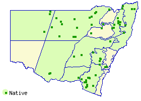
Distribution and occurrence: The taxon is widespread in southeastern Australia. It occurs south from Stanthorpe in Queensland, as well as west in the Warrego and Darling River systems. In New South Wales, it occurs along the Great Dividing Range from Armidale, through the Blue Mountains, along the Southern Highlands and alpine areas of Kosciuszko National Park. In Victoria, it also occurs in alpine areas along the Great Dividing Range and as far south as Port Phillip as well as to the west across mountain areas and in the Delatite, Delegate and Dry River systems. It also occurs along entire length of the Murray River system. It is rare in Tasmania where it occurs in the Ouse River system. In South Australia, it occurs in higher altitudes, in the Mt Gambier area, as well as the entire length of the Mt Lofty Ranges to Fleurieu Peninsula and Kangaroo Island. Locally common, widespread herb growing in wet areas amongst grasslands, herblands, sedgelands, lignum thickets in swamps, along watercourses particularly after flooding or underlying in open woodlands or Acacia or eucalypt forest; rarely in disturbed areas such as roadside drains or dams. Most commonly found in higher altitude areas of ranges above 500 m, rarely found at sea level, where it is associated with large rivers. Grows in rich soils of basalt origin or deep cracking clays through to light sandy soils derived from granites.
NSW subdivisions: NC, NT, CT, ST, CWS, SWS, NWP, SWP, NFWP
Other Australian states: Qld Vic. Tas. S.A.
Text by L. Murray
Taxon concept: Miller, C.H. & West, J.G. (2012) J. Adelaide Bot. Gard. 25: 35 & 36
APNI* Provides a link to the Australian Plant Name Index (hosted by the Australian National Botanic Gardens) for comprehensive bibliographic data
***The AVH map option provides a detailed interactive Australia wide distribution map drawn from collections held by all major Australian herbaria participating in the Australian Virtual Herbarium project.
|