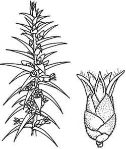
Common name: Urn-heath
Melichrus urceolatus R.Br. APNI* 
Description: Erect, stiffly branched shrub, 20–150 cm high, lignotuber present.
Leaves usually spreading to reflexed, 6–25 mm long, 1.6–6.2 mm wide, glabrous to scabrous, deeply 6–12-ribbed on lower surface; base sometimes ± sheathing; margins narrow-hyaline, densely toothed; petiole 0.5–1 mm long.
Flowers crowded near branch bases, white, cream or yellow-green; bracteoles 2.5–3 mm long. Sepals 5–7 mm long, cream-green, glabrous or hairy. Corolla tube urceolate, 4–5 mm long; lobes 2–3.5 mm long, with sparse long hairs near apex and throat.
Fruit depressed-globose, c. 4 mm long, greenish white or purple-brown.
Flowering: March–November
Distribution and occurrence: Grows in dry sclerophyll forest, Callitris woodland and Acacia scrub on skeletal, sandy or loamy soils; widespread.All divisions except NFWP & SFWP; Qld, Vic.
NSW subdivisions: NC, CC, SC, NT, CT, ST, NWS, CWS, SWS, NWP, SWP
Other Australian states: Qld Vic.
Text by J. M. Powell, except for groups with contributors listed
Taxon concept: Flora of NSW 3 (1992)
ECOLOGY
Life History
Vegetative spread No (McIntyre et al. 1995).
Flowers White, cream or yellow-green, March--November.
Fruit/seed Succulent fruit (drupe), 4 mm long, greenish white or purple-brown, July--November.
Dispersal, establishment and growth Diaspore: fruit, adaptation for dispersal by ingestion (McIntyre et al. 1995).
Fire response Regrowth from surviving rootstocks, no seedlings recorded less than 1 year after fire (Purdie 1977).
Interaction with other organisms Flowers eaten by Crimson Rosella Platycercus elegans (Lepschi 1993).
Habitat
Habitat Steep slopes, hillsides.
Altitude 0--1200 m
Annual rainfall 700--1000 mm
Typical local abundance Occasional--frequent.
Vegetation Eucalypt woodland e.g. with Eucalyptus eximia, E. gummifera, E. sclerophylla, E. sparsifolia, E. rossii, E. macrorhyncha, E. dives, E. mannifera, Callitris woodland and Acacia scrub.
Substrate Sandy or loamy soils on sandstone, acid volcanics, shaley soils, sometimes on disturbed sites.
APNI* Provides a link to the Australian Plant Name Index (hosted by the Australian National Botanic Gardens) for comprehensive bibliographic data
***The AVH map option provides a detailed interactive Australia wide distribution map drawn from collections held by all major Australian herbaria participating in the Australian Virtual Herbarium project.
|


